 |
| Map of rivers and brooks in London |
From the map you will see that there are many brooks and rivers running through London, joining others and flowing into the Thames at various points. I have walked the route of the Westbourne (all eight miles of it), Beverley Brook and the Hogsmill. I came away from this exhibition enthused to do more.
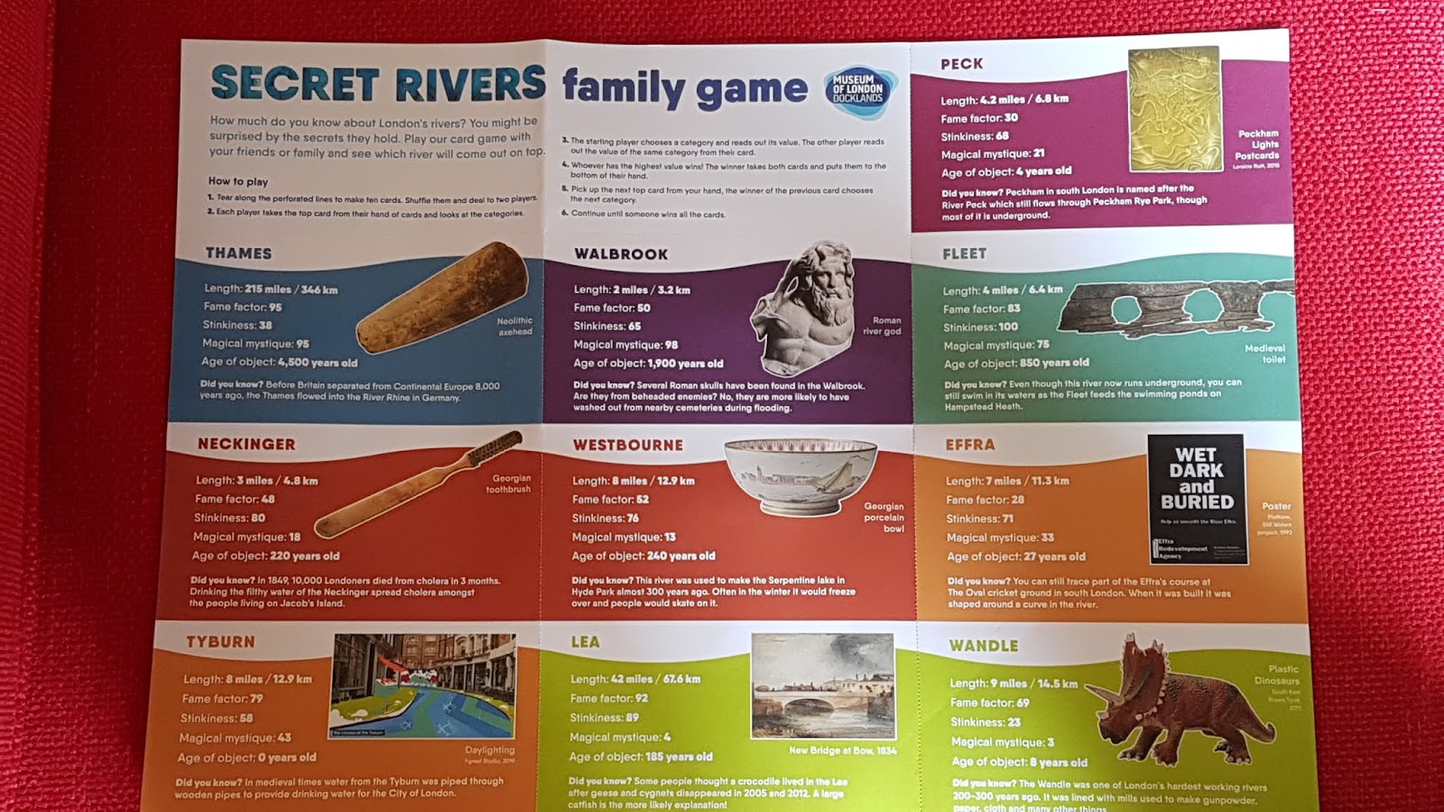
Secret Rivers features just ten of these rivers - the main one of course is the Thames. At 215 miles I've yet to complete it but have almost walked the whole of the London section and a few miles beyond (basically I've walked from Staines to Erith, including both north and south banks in London). As you can see I am rather obsessed!
The other nine rivers featured are Neckinger (already mentioned), Tyburn (8 miles), Walbrook (2 miles), Westbourne (8 miles), Lea (42 miles), Peck (4.2 miles), Fleet (4 miles), Effra (7 miles) and Wandle (9 miles). Each one featured has basic details and finds (treasure) in cabinets. I was amazed to see how the River Fleet once looked, thriving with boats and activity (see photo). Most of these rivers have long since been built over, though Platform are campaigning for rivers to be exposed where possible. At present they are concentrating on the Effra. I would love this to happen! On the whole the only way you might know there was a river nearby is through the way roads curve and follow the route, road names (like Effra Road) and by listening through certain manhole covers (if you don't mind people thinking you are crazy!).
There is so much history to these rivers and if I could go back to the pre-historic times. I'd love to walk the Thames marshes in Stone Age days, a period that fascinates me.
As part of the exhibition there is a film showing some of the old rivers and the sewers built by Joseph Bazalegette after the big stink of 1858. A truly amazing feat.
There are activities for children, things to smell and to discover and I picked up the Family Game Cards because of the information it provides, including the wonderful map. You can download a 32 page digital catalogue (see the notice on the wall before entering the exhibition for information).
The exhibition is on until 27th October and is free. There is lots more information about London's lost rivers here.
 |
| The Fleet River |
 |
| See picture below |


 |
| The Neckinger River near Jacob's Island |
 |
| Map of the Cholera epidemic |

 |
| Useful info |
Comments
Post a Comment